An easy trail, flat close to Base Camp.
This trail is intended for walking and is not suitable for bikes.
Download the Dale’s Trail PDF file.
Located at Base Camp, we offer 3 complimentary trails for guests just wanting a short hike to stretch their legs.
These trails include: Dale’s Trail, Forestry Walk and John’s Trail
All spring/summer/fall property access beyond the red gates requires a Property Access Permit.
An easy trail, flat close to Base Camp.
This trail is intended for walking and is not suitable for bikes.
Download the Dale’s Trail PDF file.
An easy trail, flat, close to Base Camp, winding through a maple and beech stand. Perfect during all seasons if you’re looking for some fresh air! There are a few wet and muddy spots but some wooden bridges and board walks will help you to cross.
Look for interpretive signs along the trail if you wish to learn more about the trees surrounding you!
This trail is intended for walking and is not suitable for bikes.
Download the Forestry Walk PDF file.
An easy trail, flat close to Base Camp, winding through an old blowdown with balsam fir, turning into maple forest. Perfect in the summer if you are looking for some fresh air! There are two creek crossings that involve stepping over some rocks.
This trail is intended for walking and is not suitable for bikes.
Download the John’s Trail PDF file.
Very scenic road through small rolling hills along multiple lakes.
The road can be a bit busy during summer, so please be careful.
Download the East Road PDF file.
Wide, hard packed road offering rolling hills along a few lakes and wetlands. This road does accommodate a varying degree of vehicular traffic, which should be taken into account! Ride single file on the right-hand side only.
Download the Greif Road PDF file.
Wild Woods Walk is an easy to moderate trail close to Base Camp. The trail passes through rolling terrain with an amazing variety of trees and plants. Along your way you will find some informative signs about the plants and wildlife in this area.
At the beginning of the top side of the trail, you can see some semi-permanent pieces of land art from the Forest Art Project, installed between 2008 and 2011.
Download the Wild Woods Walk PDF file.
This single tracked trail offers a few steep hills, very dense wooded parts, and nice grassy stretches. It is a good hiking trail, and moderate for mountain biking.
Download the Ben’s Trail PDF file.
Length: 3.6 km Rating: Moderate
This single track trail is best ridden from Clear Lake towards Marsh Lake. It’s a great and wonderful trail, offering a rewarding challenge to anyone. At the same time, it is scenic, meandering through the forest, passing ponds and wetlands. Plan a stop at the Marsh Lake Lookout overlooking one of the most extensive marshlands in this part of the province!
Download the Krista Trail PDF file.
This trail is one long and gradual uphill, then makes its way down. It is a hard-packed single track with some marshy and sandy sections.
This is a great trail combined with Krista Trail.
Download the Greg Trail PDF file.
This trail can be clearly divided in two sections: the northerly portion is a wide, well–packed, easy-to-ride access road; the southerly portion is more difficult, with some wet and muddy sections (which should be avoided in the early part of the season, or during wet conditions).
The trail goes along many wetlands and a creek. Most hills are not steep.
Download the Black Creek Trail PDF file.
Conveniently located close to Base Camp, this single track trail is scenic, passing through a couple of nice wetlands and hardwood and hemlock stands. Some parts can be wet and muddy at the beginning of the season or under wet conditions, and there are a few rocky areas. This is a moderate trail for biking but it offers a good hike.
Download the Dog Trail PDF file.
This trail section has a potential to be wet and muddy in spots. However, it offers nice sections staying on the high sides, meandering through pristine forest. It offers a nice long ride combined with King & James Trail or Green Trail.
Download the Red Trail Central PDF file.
This trail is a logging access road mainly used for snowmobiling in the winter, winding through hardwood stands. The trail tends to be wet in the early season. The top and the bottom sections are packed and graveled.
You can decide half way to go back on Dutton Road via Moose Trail, or on North Road via a trail south of Depot Lake.
Download the Red Trail North PDF file.
A moderate, scenic trail, which offers a long, gradual uphill, followed by a refreshing, great downhill towards Red Trail.
Download the Green Trail PDF file.
A nice trail if you don’t like rocky terrain. The southern and northern ends of this trail are a well-maintained road, gently leading over hills; near the middle of the route it gains a few steep sections that can become muddy after heavy rain.
The best season for hiking or biking this trail is August through October.
Download the Sunday Trail PDF file.
While the southern section of Sprucetree Trail is a winter trail only, the northern part between Sunday Trail and Nugget Road is a nice biking and hiking trail. From Nugget Road the trail gently climbs up a hill next to Lost Lake and then continues across two more hills towards Sunday Trail. From there, explorers can either go north and loop back to Nugget Road, or go for a longer ride down the southern part of Sunday Trail.
The best season for hiking or biking this trail is August through October.
Download the Sprucetree Trail PDF file.
One of the most favoured trails in Haliburton Forest, the King & James trail offers the best a biker could hope for: it is a hard-packed trail, while the eastern portion is graveled. Enjoy the view of some wetlands and creeks!
Download the King & James Trail PDF file.
With a wide track, this trail offers some great technical riding for bikers: some steep inclines with rewarding downhills, rocky and muddy sections, and full of challenges.
Sections of this challenging trail may be muddy under wet conditions, while others are very rocky. Although wide, the trail offers some very technical riding.
On the softer side for a trail, beware of obstacles hidden under tall grass and vegetation.
Download the Kendra Trail PDF file.
This trail is a combination of single tracks and wider logging trails through a variety of landscapes and terrain. This trail can be fairly wet during the early spring, summer and fall months as it is low lying.
After a rugged uphill at the north end, the trail offers the best ride from north to south. It is hard packed, well marked and defined.
Download the Poacher’s Trail PDF file.
A short trail section which serves as a connector between Blue Lake and the Redstone Vista Trail. The scenery complements the difficult terrain.
Download The Pass Trail PDF file.
This trail offers a challenging climb and an even more challenging descent with sections of loose rubble. It is best ridden from Blue Lake (west to east). The view to the south across Pelaw and Redstone Lakes is rewarding. Use extreme caution on your descent.
Download the Redstone Vista Trail PDF file.
This trail is probably our most technical trail, winding through pristine scenery and mature stands of hemlock. It hosts some rocky outcrops and short sections with many roots. The uphills and downhills are both fun and negotiable. The trail is well defined and mostly hard-packed, with only a few wet spots which disappear with dry weather. Enjoy the spectacular viewpoints looking across MacDonald Lake!
This is a great trail to combine with Krista Trail.
Download the Normac Trail PDF file.
North Shore Trail is one of the most difficult mountain bike trails, and it is great for hiking.
This single track trail travels along a steep ridge line, and there are a few very steep sections. The trail goes along Clear Lake, and gets quite close to the shoreline.
Download the North Shore Trail PDF file.
A short but difficult and twisted single track trail, especially for bikers, due to a few short and steep inclines where pushing the bike is sometimes necessary. It is best ridden north to south to avoid more uphill sections.
Download the Chico Trail PDF file.
This single track trail hosts one monster hill, but don’t let that deter you, because once you reach the loop area near the top, there are two spectacular views: one looking across an expanse of forest, and the other over Black Lake, making the uphill effort worthwhile!
Download the Lookout Trail PDF file.
Twin trail to the Lookout trail, the Outlook Trail is longer and hosts an even bigger hill than the Lookout Trail, but once again the view at the top makes the uphill trek truly rewarding.
Download the Outlook Trail PDF file.
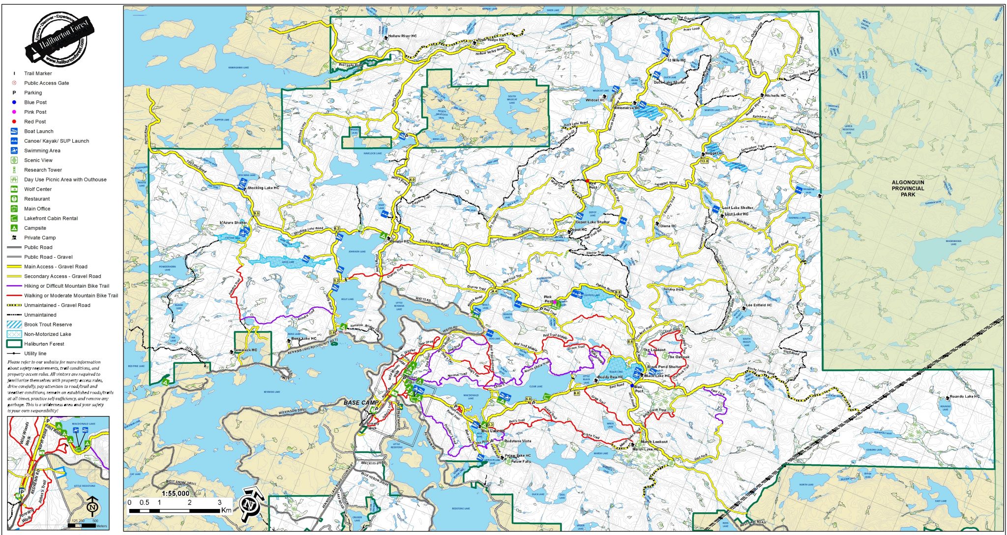
Summer Trail Map
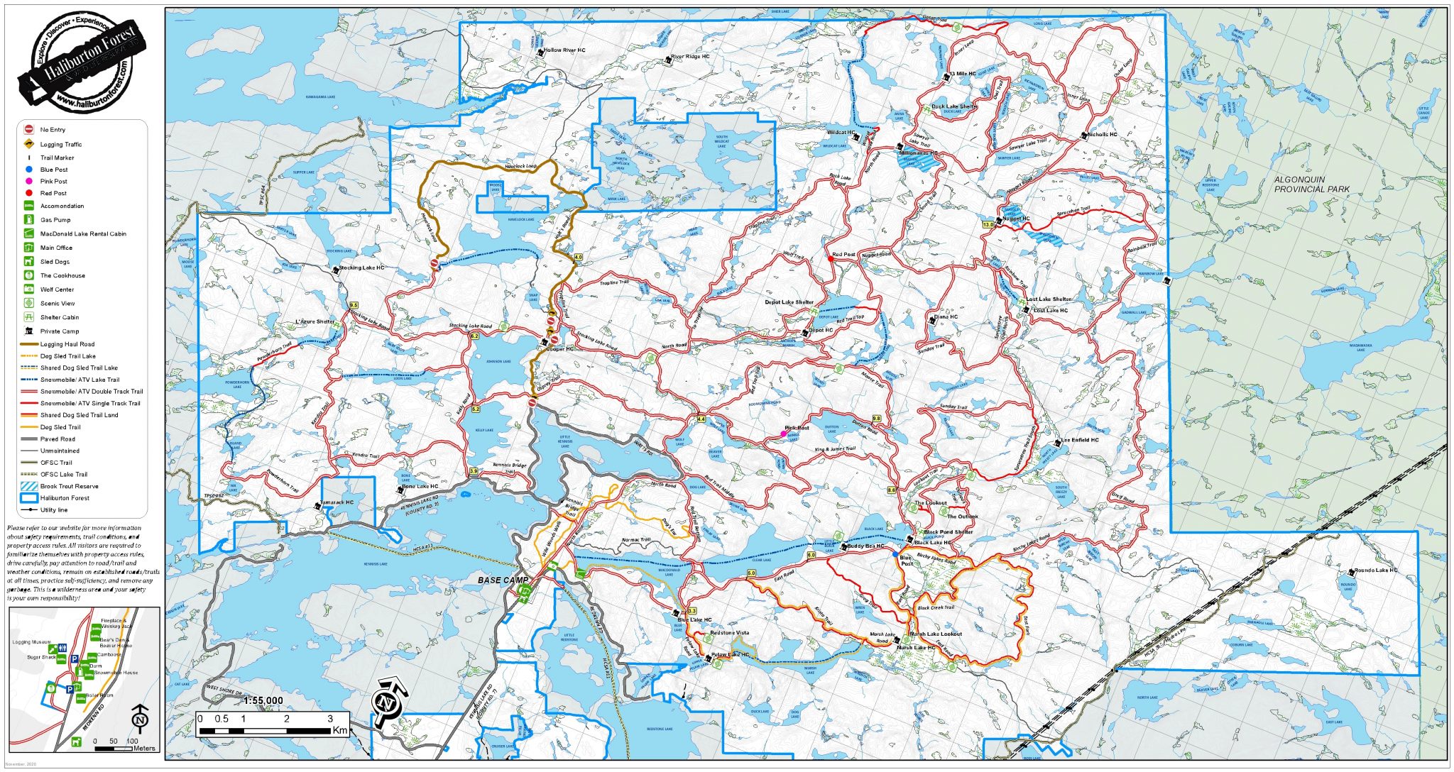
Winter Trail Map